
Blah blah blah introduction. Perhaps I should go with that.
Seriously, though. We’re at the end of Summer 2021, and the best thing I can say is that we’re not having to deal with a Presidential campaign again. COVID is still here, however, impacting travel. I did get some travel in over my summer, with drives to Los Osos, Scottsdale, and Las Vegas, and exploration of the Route 166 corridor and the Route 58 corridor between I-15 and Route 14. I got to see the construction they are doing S of Mojave on Route 14, and got to kill off a load of podcasts. Hopefully you’ve had a safe summer. As always: Please make sure you are vaccinated, and please continue to wear masks. Neither complete eliminates risk, but they are both key factors in reducing risk to an acceptable level. As someone who has been working in Cybersecurity for over 35 years, I understand how being risk adverse can blind you to the importance of doing the simple things to reduce risk. Just as with our highways, our goals should be to reduce the risks whereever we can.
On to the updates.
Updates were made to the following highways, based on my reading of the papers from the last week of May 2021 through xxxx 2021 (which are posted to the roadgeeking category at the “Observations Along The Road” and to the CaliforniaHighways Facebook group) as well as any backed up email changes. I also reviewed the the AAroads forum (Ꜳ). This resulted in changes on the following routes, with credit as indicated [my research(ℱ), contributions of information or leads (via direct mail or ꜲRoads) from Anthony R. Brooks(1), Tom Fearer(2), Brian Nordon(3), Tony Ortega(4), Scott Parker(5), Joe Rouse(6), Chris Sampang(7), Carol Stephens(8): Route 1(ℱ,2), Route 4(ℱ), Marine Route 5 (M-5)(ℱ), I-5(ℱ,2), Route 11(ℱ), Route 16(2), Route 17(ℱ), Route 18(ℱ), Route 25(ℱ), Route 29(ℱ), Route 33(2), Route 35(ℱ), Route 36(ℱ), Route 37(ℱ), Route 41(ℱ,2), Route 46(ℱ,2), US 50(ℱ,2), Route 58(6,5), Route 71(ℱ), Route 74(ℱ), Route 77(ℱ,1), I-80(ℱ,2), Route 88(ℱ), Route 91(ℱ,1,4), Route 99(ℱ,2), US 101(ℱ,2), Route 110(ℱ), Route 113(2), Route 121(ℱ), Route 132(ℱ), Route 135(ℱ), Route 136(3), Route 140(ℱ), LRN 148(ℱ), Route 152(ℱ), Route 156(ℱ), Route 166(ℱ), Route 174(ℱ), Route 176(ℱ), Route 187(ℱ), Route 207(ℱ), Route 247(ℱ), Route 249(8), Route 273(ℱ), Route 275(2), Former US 399(2), US 395(ℱ), I-405(ℱ), I-580(ℱ), Marine Route 580(ℱ), I-680(ℱ), I-710(ℱ), County Sign Route A13(ℱ), County Sign Route 66(7).
(Source: private email, Highway headline posts through August 2021 as indicated, AARoads through 09/05/2021)
Updated the links to the Cal-NexUS pages and the highway exits, because Caltrans went and moved things again(ℱ). Updated the El Camino Real Bells page to reflect the removal of the El Camino Real bell from downtown Santa Cruz, and the rationale therefore(ℱ). Updated the Statistics page to better reflect the shortness of Route 77(1).
 Added information on the National Marine Highway System(ℱ):
(Source: CleanTechnica, 6/22/2021; US DOT Maritime Administration: National Marine Highways, 6/2021)
In California waters, there are two routes: Route 5 (M-5) and Route 580 (M-580). The US Department of Transportation has a special webpage all about this system of marine highways, complete with a map of the system. The system’s highways are numbered the same as nearby Interstate Highways from which they could relieve congestion. The DOT Maritime Administration (MARAD)’s Marine Highway Program has one major goal: expand the use of America’s navigable waters. They closely with public and private organizations to:
- Develop and expand marine highway service options and facilitate their further integration into the current U.S. surface transportation system, especially where water-based transport is the most efficient, effective and sustainable option
- Highlight the benefits, increase public awareness and promote waterways as a viable (in some cases a superior) alternative to “landside” shipping and transportation options
The Marine Highway system currently includes 26 “Marine Highway Routes” that serve as extensions of the surface transportation system. Each all-water route is designated by the Secretary and offers relief to landside corridors suffering from traffic congestion, excessive air emissions or other environmental challenges. For the highways in California, a section was added to the appropriate route page providing information on the Marine highway route.
Reviewed the Pending Legislation page, based on the California Legislature site. As usual, I recommend to every Californian that they visit the legislative website regularly and see what their legis-critters are doing. As many people are unfamiliar with how the legislature operates (and why there are so many “non-substantive changes” and “gut and amend” bills), I’ve added the legislative calendar to the end of the Pending Legislation page. Noted the passage of the following:
( Read more... )
 Rosh Hashanah, the Jewish New Year, starts at sundown tomorrow (Tuesday) night, September 7th. Thus, it’s time for my annual New Years message for my family, my real-life, Blog, Dreamwidth, Google+, Tumblr, Twitter, and Facebook friends (including all the new ones I have made this year), and all other readers of my journal:
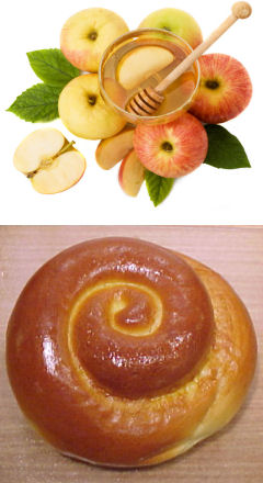 Another traditional food is a
 Recently, I was in Las Vegas. While there, I visited my favorite hangout,